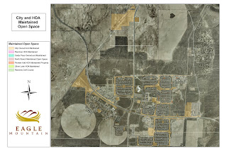
My internship gave me experience in two separate fields. Since the city is still pretty small, Geographic Information Systems (GIS) and planning are closely related. When I started my internship in May 2010 I had a long list of GIS projects to complete. My duties as a GIS Intern were to create a city atlas to be put online as well as create a database to insert information that is important to the city residents. Information such as school boundaries, voting districts, garbage and recycle pick-up, speed limits, address, lot number, open space information, etc. I need to first create a map to belong in the city atlas and then insert the information gained from each map and insert into the database. I will inlcude screen shots in the next couple posts of the database to demonstrate what the information I collected looks like. Below I have inserted pictures of the maps created to demonstrate the available open space. Each map explains who owns the open space and who is in charge of maintaining the space (either the HOA or Eagle Mountain City). Hopefully the maps turn out large enough.
.jpg)
The map above shows the community around the city center. This community is located in the center of the city boundaries.
.jpg)
The map above is the community that is located on the northern most boundary of Eagle Mountain.
.jpg) The map above shows the community around the city center. This community is located in the center of the city boundaries.
The map above shows the community around the city center. This community is located in the center of the city boundaries..jpg) The map above is the community that is located on the northern most boundary of Eagle Mountain.
The map above is the community that is located on the northern most boundary of Eagle Mountain.
Wow that is some amazing work! That is such a useful tool. I will admit I had no idea how much work was involved in that process, prior to reading you post. Great job! Sounds like such a great internship.
ReplyDeleteSam, I'm shock as you. Steven work is very impressive. He has done a lot of good and important things in his life. He has accomplished amazing things in a young age. Additionally, your internship is wonderful and interesting. I like what you do for the city of Utah. I also love the city map you provided for us. Congratulations! I wish you a good luck.
ReplyDeleteRegarding your goal of creating safe environments for families (admirable!) what would you do with the empty land that shows on your maps? I am a childless urban dweller, and I wonder what family-oriented people want in their communities.
ReplyDeleteHow do you gather the information you put on your map? Are there surveys that are compiled? This is so interesting, and I feel we've only heard the tip of the iceberg!